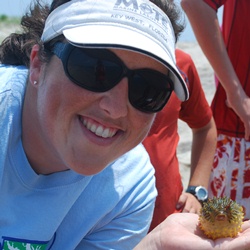
Sarah McGuire, education coordinator for the Chesapeake Bay National Estuarine Research Reserve in Virginia (CBNERRVA), helps students connect with the Chesapeake Bay. One way she accomplishes this is by using CBIBS data in several CBNERRVA education programs—including “Chesapeake Studies,” a program for seventh graders in Gloucester, Mathews, and York Counties, which is funded by the NOAA Chesapeake Bay Office’s B-WET program.
In Chesapeake Studies, students are introduced to the concept of water quality by testing water from sites along the York River in the classroom and by exploring the Virginia Estuarine and Coastal Observing System (VECOS).
“We ask students how we could monitor the health of the Chesapeake Bay without having a person sample water every day, all year long,” Sarah describes. “'Technology’ is typically an answer provided, and then we show the students the CBIBS website and the capabilities of the data sensors.”
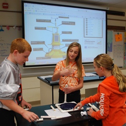
 Students then build their own buoy to investigate buoyancy, stability, and a buoy’s ability to hold weight (in this case, golf balls—representing data sensors).
“One of the features we especially like to use during our Build-a-Buoy activity is the About the Buoy Technology diagram because it shows students all of the necessary sensors that are found on an observation buoy. When students are planning the construction of their buoy, it is useful to show them how the actual buoys are balanced and built to be not only buoyant but hold a certain amount of weight,” Sarah explained.
“Through this project, seventh-grade students are introduced to the variety of STEM careers available to them—from purely science and research to a more engineering-based career. The use of technology (accessing the data via the computer and their personal smartphones) also increases students’ excitement about the project,” Sarah emphasizes. “CBIBS provides very up-to-date information, and the students are always surprised that we can receive data from just several minutes ago from a buoy that is an hour or so away from them.”
Sarah uses the Jamestown, Norfolk, and First Landing buoys the most because they are the closest to the Virginia Institute of Marine Science where she works, and are the most relevant to the students they work with.
When she’s not teaching young stewards of the Chesapeake about their Bay, Sarah enjoys hobbies including kayaking around the Jamestown buoy area. While she uses CBIBS primarily for educational purposes, Sarah sees a wider applicability for the data, and appreciates how easy it is to get the data: “Having the capability to call into the buoys for information, or accessing the information through the apps, makes the data that much more accessible for any user—from a middle school student to an adult."
Photo of Sarah thanks to Sally Upton; photo of students doing the Build-a-Buoy activity thanks to Sarah.


