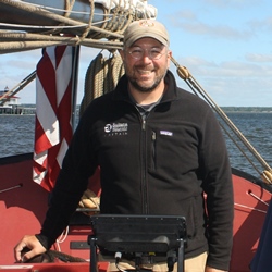
Captain Michael Fiorentino spends a lot of time on the Chesapeake as captain of the Sultana Education Foundation’s schooner, the Sultana, so he uses CBIBS a lot, too.
While the Sultana is most often used as a platform on which students learn more about the Bay and for public sails, the Sultana is apparently also a speed demon. Sultana captured first place in her class in the 2016 Great Chesapeake Bay Schooner Race. Congrats!
“I use the CBIBS data to verify weather forecasts,” Michael described. “The buoys offer great observational verification of the weather forecasts. It is often helpful to have the meteorological data on hand when we are far up a river. It can be very pleasant up the river in Chestertown and howling out in the Bay. The buoys update so often it is ostensibly real time data. Having data like that available helps us to make decisions about how we will operate the boat in a safe and enjoyable manner.”
While Michael used to access data from the CBIBS buoys via the NOAA National Data Buoy Center, he now uses the CBIBS Smart Buoys app on his iPhone. He finds the app updates very quickly, is easy to use, and is very exact. The Sultana generally operates in Maryland waters—so Michael uses data from the Patapsco and Gooses Reef buoys, as well as the Annapolis buoy on occasion.
“The wind speed, wind gust, and wind direction are the most useful. It helps me figure out if we will be sailing the boat or motoring. I also look at the wave information and the air pressure. The wave data can help me make decisions about whether or not we should stay in the rivers or venture out into the Bay,” Michael noted. “The air pressure data can be very helpful when looking at the buoys further away to determine if a front is crossing the Bay.”
So far, the team on the Sultana has mostly used CBIBS to help ensure safe time on the water. But Michael is exploring how CBIBS is a part of the Captain John Smith and Star-Spangled Banner National Historic Trails as well as water-quality data the buoys track to see how they can use that information with students.
Even when he’s not at work, Michael checks in with CBIBS, as he spends time on the Bay for fun as well. “From my perspective the meteorological data is priceless. It can paint a very clear picture of what the Bay looks like at any moment and offer clear help in making operational decisions. Any person out on the water, for work or recreation, can use the data to have a safe and pleasant experience.”
We’ll see you on the water, Michael!


